Treaty of Neuilly-sur-Seine
| Treaty of Neuilly-sur-Seine | |
|---|---|
 Bulgaria after Treaty of Neuilly-sur-Seine
|
|
| Signed Location |
27 November 1919 Neuilly-sur-Seine, France |
| Signatories | Other Allied Powers
|
| Depositary | French Government |
| Languages | French (primary), English, Italian |
The Treaty of Neuilly-sur-Seine, dealing with Bulgaria for its role as one of the Central Powers in World War I, was signed on 27 November 1919 at Neuilly-sur-Seine, France.
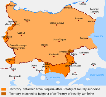
The treaty required Bulgaria to cede Western Thrace to the Entente, (which ceded it to Greece at the San Remo conference) thereby cutting off its direct outlet to the Aegean Sea and an area of 2563 km² on the western border to the Kingdom of Serbs, Croats and Slovenes. The treaty also forced Bulgaria to return Southern Dobruja, which had been captured during the war and restored the border set by the Treaty of Bucharest (1913). Bulgaria was also required to reduce its army to 20,000 men, pay reparations exceeding $400 million, and recognize the existence of the Kingdom of Serbs, Croats and Slovenes. The signing ceremony was held in Neuilly's town hall (hôtel de ville).[1]
In Bulgaria, the results of the treaty are popularly known as the Second National Catastrophe. Bulgaria regained South Dobrudja as a result of the Treaty of Craiova and during World War II together with Nazi Germany, temporarily reoccupied most of the other territories ceded by the treaty.
Contents |
Territories ceded to the Kingdom of Serbs, Croats and Slovenes
Four minor regions (historiographically referred to as the Western Outlands by Bulgarians) had formed a part of Bulgaria (excluding the region around Strumitsa, which became part of Bulgaria in 1912) from its inception as a principality in 1878. Bulgaria became internationally recognised as an independent country in 1908 and controlled these territories until 1919 when they were ceded to the Kingdom of the Serbs, Croats and Slovenes (later renamed to the Kingdom of Yugoslavia) under the Treaty of Neuilly. The cession of the region was partly a compensation for the occupation of the southern and eastern part of Serbia by Bulgarian troops in the period between 1915 and 1918 and partly served strategic grounds. The old political boundary between Bulgaria and Serbia followed a chain of high mountain ridges, whereas the new one gave significant military and strategic advantages to the Serbs exposing dangerously the Bulgarian capital of Sofia and thus reducing significantly the military threat for eastern Serbia in case of a new Bulgarian invasion (see also Balkan Wars and World War I).
The Treaty of Neuilly was one in the series of treaties after the World War I (like the Treaty of Versailles, Treaty of Saint-Germain, Treaty of Trianon, Treaty of Sèvres) which were meant to diminish the military and political strength of the defeated members of the Central Powers. As a result of this, some areas with absolute Bulgarian majority (such as Bosilegrad and a part of the Dimitrovgrad municipality) were ceded to Serbia (within the Kingdom of Serbs, Croats and Slovenes).
Bulgarian sources claim that the treaty was to last for twenty years and that all territories should have been returned to Bulgaria in 1939, but that was not specified in the treaty.
Region and population
Territories ceded by the treaty to the then Kingdom of Serbs, Croats and Slovenes cover an area of 1,545 km² in what is now Serbia and 1,028 km² in what is now the Republic of Macedonia.
In Serbia, to which the term generally applies in Bulgaria, the territory ceded is split between the modern Serbian District of Pirot (municipality of Dimitrovgrad and smaller parts of the municipalities of Pirot and Babušnica) and District of Pčinja (municipality of Bosilegrad and a small part of the municipality of Surdulica). It also includes a small section along the Timok River in the municipality and District of Zaječar, composed by eight localities (seven populated by Vlachs and one populated by Bulgarians).[2]
In 1919, the area corresponded to the following parts of the Bulgarian okrugs: Kyustendil, 661 km², Tzaribrod 418 km², Tran 278 km², Kula 172 km² and Vidin 17 km². Bulgarian sources claim that the Bulgarian population made 95% of the population in Bosilegrad and 75% of the population in Tzaribrod at the time. In the Yugoslav census of 1931, all South Slavs were simply counted as Yugoslavs (Serbs, Croats, Slovenes, Bulgarians) so a comparison could not be made. According to the last Census in Serbia from 2002, Bulgarians made 50% and 71% of population in Dimitrovgrad and Bosilegrad respectively.
See also
- Bulgarians in the Republic of Macedonia
- Bulgarians in Serbia
- List of treaties
- Minority Treaties
- Western Outlands
References
- ↑ Neuilly-sur-Seine official site (in French)
- ↑ Tribalia (Blogger)
External links
|
||||||||||||||
|
|||||||||||||||||||||||||||||||||||||||||||||||||||||||||||
| Prelude | South-western front: Serbian Campaign, Macedonian front | Romanian front • Outcome • Others | Important persons |
|---|---|---|---|
|
1912–1913 1913
Neutrality
1915
 |
Commanders
Nikola Zhekov • Kliment Boyadzhiev • Georgi Todorov• Stefan Nerezov • Vladimir Vazov
Field Armies
Battles
1915 Morava Offensive Operation • Ovche Pole Offensive Operation • Kosovo Offensive Operation (1915) • Battle of Krivolak 1916 First battle of Doiran • Battle of Lerin • Battle of Struma • Monastir Offensive 1917 Second battle of Doiran • Battle of the Red Wall 1918 Battle of Skra-di-Legen • Battle of Dobro Pole • Third battle of Doiran |
Commanders
Nikola Zhekov • Panteley Kiselov • Stefan Toshev • Todor Kantardzhiev • Ivan Kolev
Field Armies
Battles
1916 Battle of Turtucaia • Battle of Dobrich • First Cobadin • Flămânda Offensive • Second Cobadin • Battle of Bucharest Outcome
1918 Treaty of Brest-Litovsk • Armistice of Focşani • Treaty of Bucharest • Protocol of Berlin Outcome
Others
|
|